

Credits
Most of the following text is derived from the book "Ithaca is Gorges: A Guide to the Geology of the Ithaca Area, Fourth Edition" by Warren D. Allmon and Robert M. Ross, published in 2007 by the Paleontological Research Institution (Special Publication No. 31).
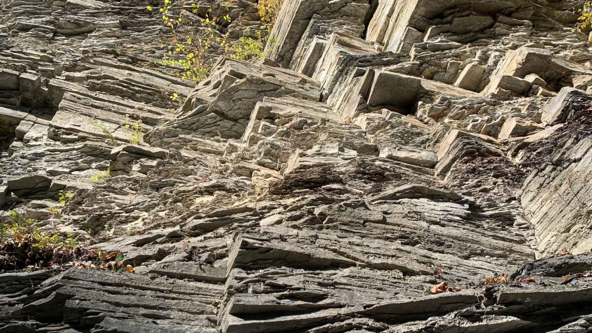
Image above: Joint surfaces exposed on Devonian-aged siltstones at Robert H. Treman State Park, Tompkins County, New York. See additional explanation below. Photograph by Jonathan R. Hendricks for PRI's Earth@Home project (CC BY-NC-SA 4.0 license).
Rocks of the Finger Lakes
When geologists study rocks, they usually try to recognize similar kinds of rocks in different places, to relate the history of one place to that of another. A layer of relatively homogenous rock that can be recognized across a reasonable distance (for example, 10-20 miles or 15-30 kilometers) is often called a formation. Formations are sometimes gathered into groups or subdivided into members. Formations, groups, and members are usually given names that relate to the places where they are best exposed (that is, not covered by soil, water, or pavement). The diagram below shows the nomenclature of formations and other units currently in use by geologists in central New York State.
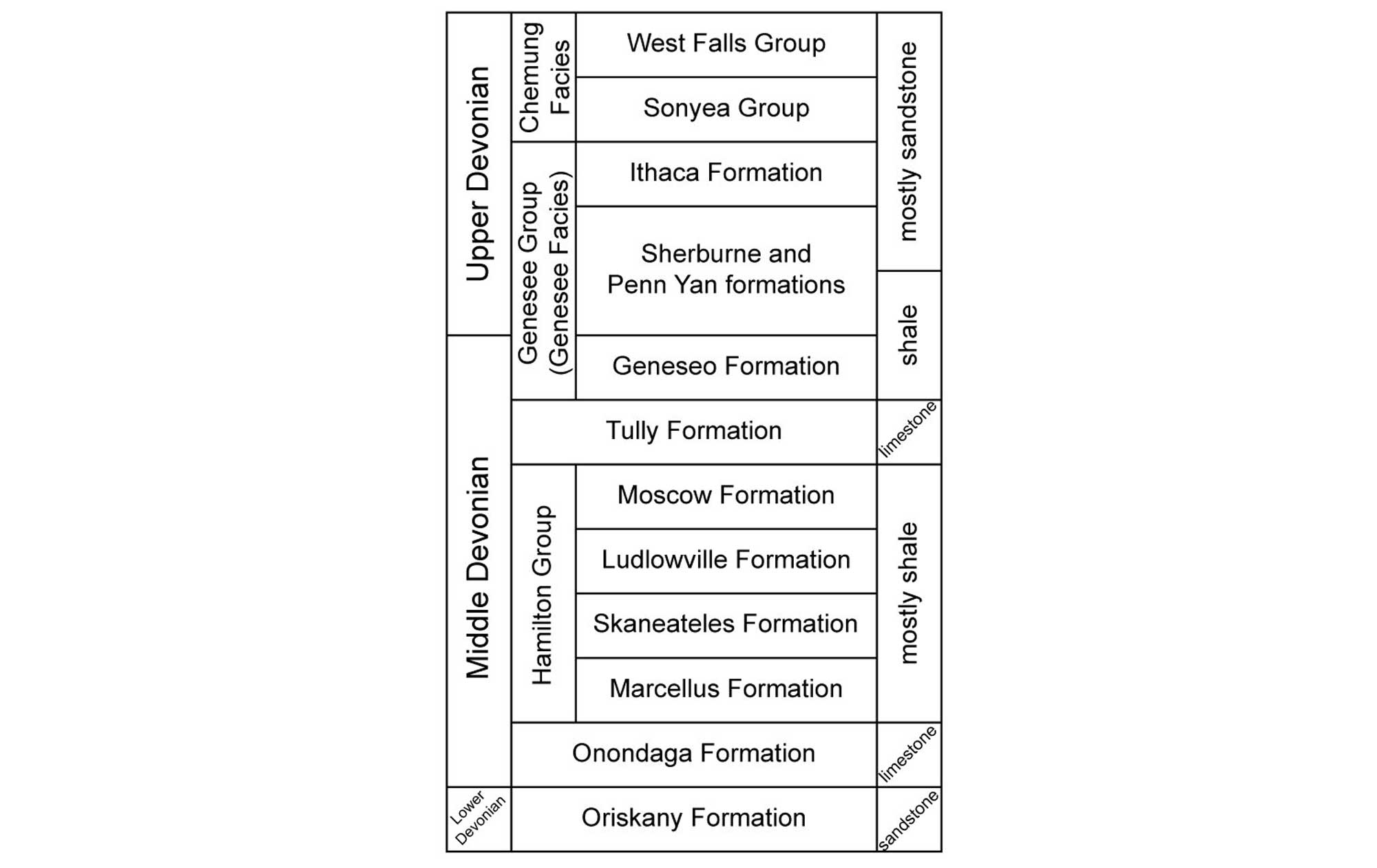
Stratigraphy of Devonian rocks in the Finger Lakes region; the oldest rocks are at the bottom. Source: Fig. 1.3 in Gorges History by Arthur Bloom (published in 2018 by the Paleontological Research Institution). Copyright Paleontological Research Institution.
Formation of the Finger Lakes
The Finger Lakes consist of 11 long, narrow, roughly parallel lakes, oriented north-south like fingers of a pair of outstretched hands.
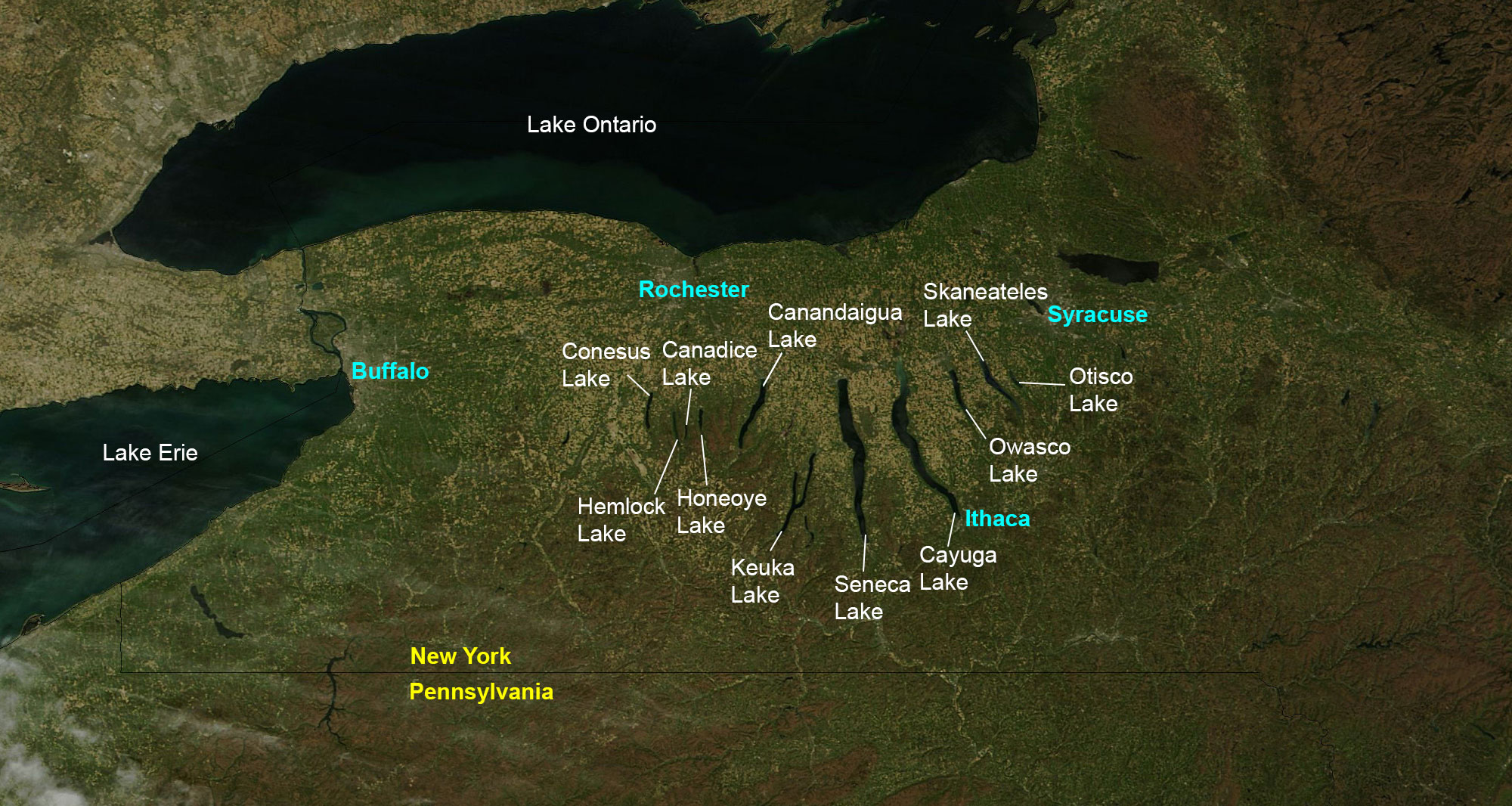
The Finger Lakes region of New York State. Image created by Jonathan R. Hendricks for PRI's Earth@Home project (CC BY-NC-SA 4.0 license). Base map from NASA Earth Observatory (public domain).
The southern ends have high walls, cut by steep gorges. Two of the lakes (Seneca and Cayuga) are among the deepest in North America and have bottoms below sea level. These lakes all formed over the last two million years by glacial carving of old stream valleys. Ithaca is located at the southernmost end of Cayuga Lake, longest and second deepest of the Finger Lakes. Cayuga is 38.1 miles (61.3 kilometers) long and 435 feet (133 meters) deep (53 feet or 16 meters below sea level) at its deepest spot. The actual depth of carved rock is well over twice as deep, but it has been filled with sediments; there could be as much as 1000 feet (300 meters) of glacial sediment in the deep rock trough below the lake bed. Seneca Lake to the west is more than 600 feet (180 meters) deep at its deepest point.
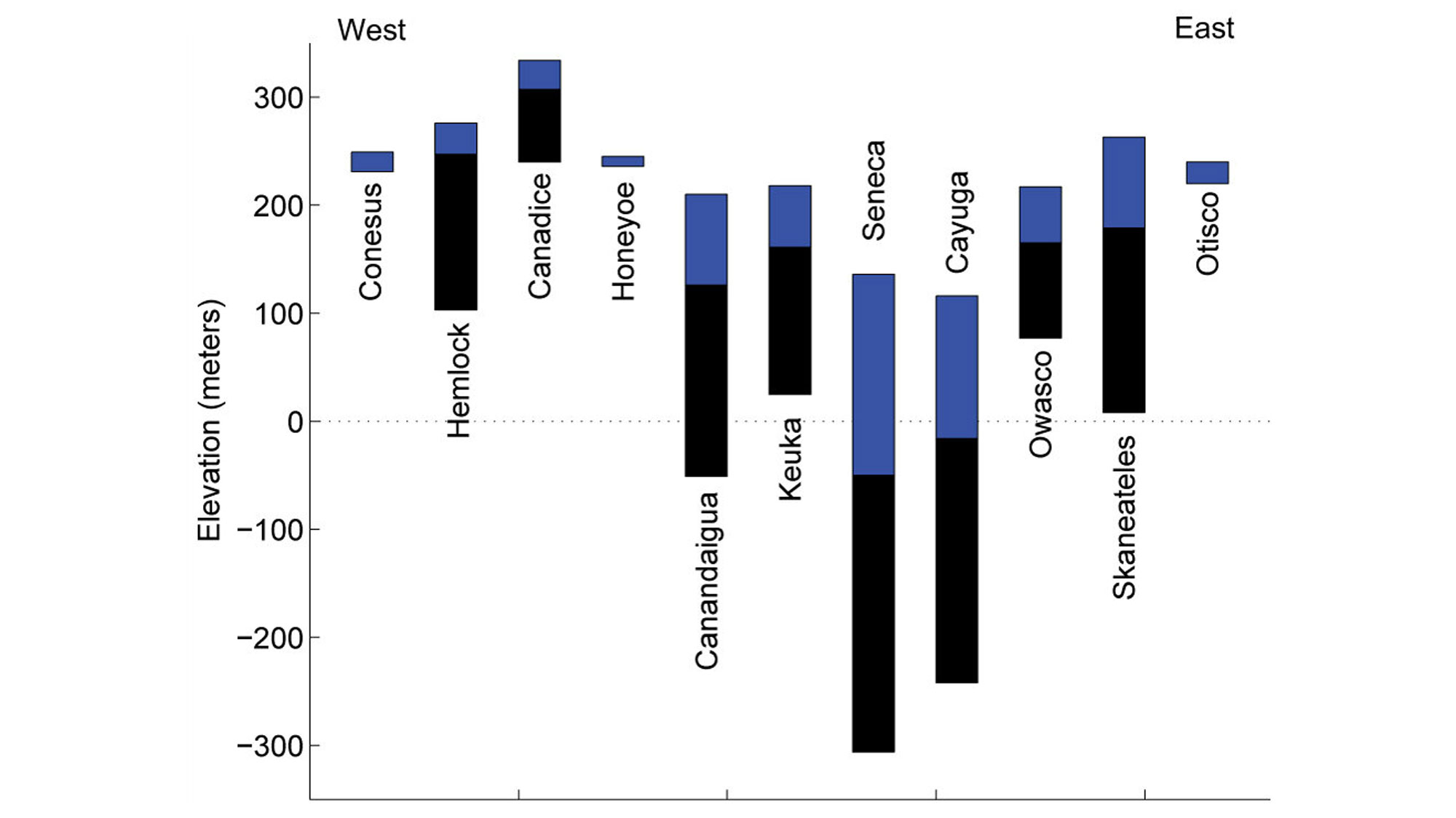
Current elevations and depths of the Finger Lakes. The blue areas represent current water depth; the black areas indicate the thickness of sediment to the maximum depth of erosion below each lake. Data are from Mullins et al. (1996). Image created by Dr. Matthew Pritchard (for educational use only) for the book Gorges History by Arthur Bloom (Fig. 5.1; published in 2018 by the Paleontological Research Institution). Copyright Paleontological Research Institution.
The Finger Lakes originated as a series of northward-flowing rivers that existed in what is now central New York State (today central New York south of Ithaca drains to the south, toward the Cheasapeake Bay, while the rest drains north and east to the St. Lawrence Seaway). Around two million years ago the first continental glaciers moved southward from the Hudson Bay area, initiating the Pleistocene glaciation, commonly known as the Ice Age. The Ice Age was really a series of many advances of glaciers (one approximately every 100,000 years). The advances are called glacials, and the retreats are called interglacials. Today we live during an interglacial.
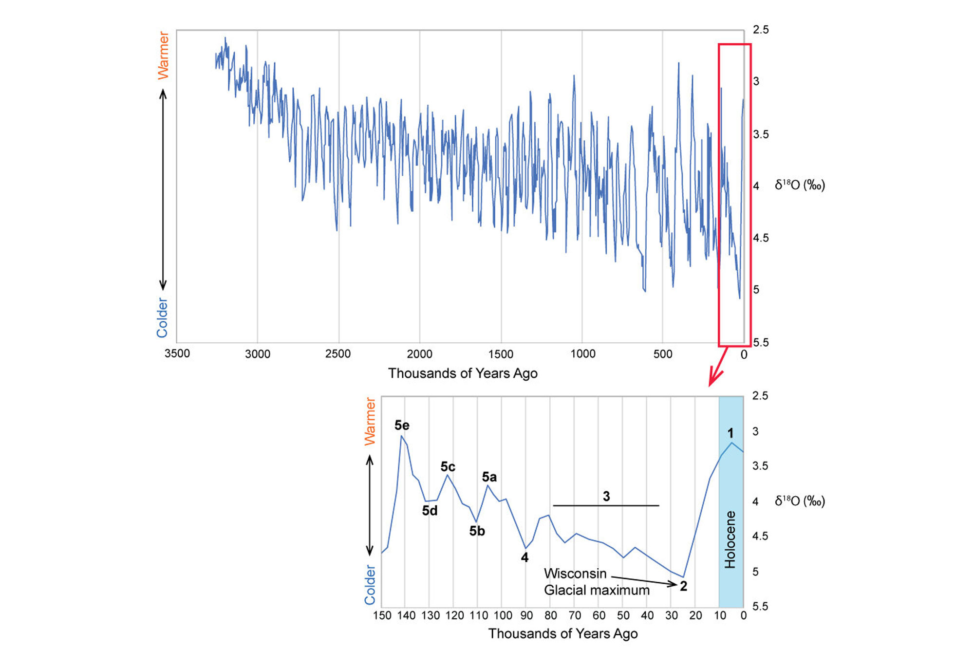
Evidence of past glacial and interglacial cycles indicated by oxygen-isotope ratios recorded in deep-sea microfossils. The top graph indicates these records over the past 3.5 million years; the bottom graph records glacial cycles during the past 150,000 years. Image by Jonathan R. Hendricks based on data originally published by Raymo (1992); published as fig. 4.1 in the book Gorges History by Arthur Bloom (published in 2018 by the Paleontological Research Institution). Copyright Paleontological Research Institution.
The Finger Lakes were probably carved by several of these episodes. Ice sheets more than 2 miles (3 kilometers) thick flowed southward, parallel but opposite to the flow of the rivers, gouging deep trenches into these river valleys. Traces of most of the earlier glacial events have been eroded away, but much evidence remains of the last one or two glacials that covered New York.
The latest glacial episode was most extensive around 21,000 years ago, when glaciers covered almost the entire state. Around 19,000 years ago, the climate began to warm, and the glaciers began to retreat, disappearing entirely from New York most recently around 11,000 years ago.
One obvious bit of evidence left by the glaciers are the gravel deposits at the southern ends of the Finger Lakes, called moraines, which are piles of rock pushed along the edge of the advancing glacier.
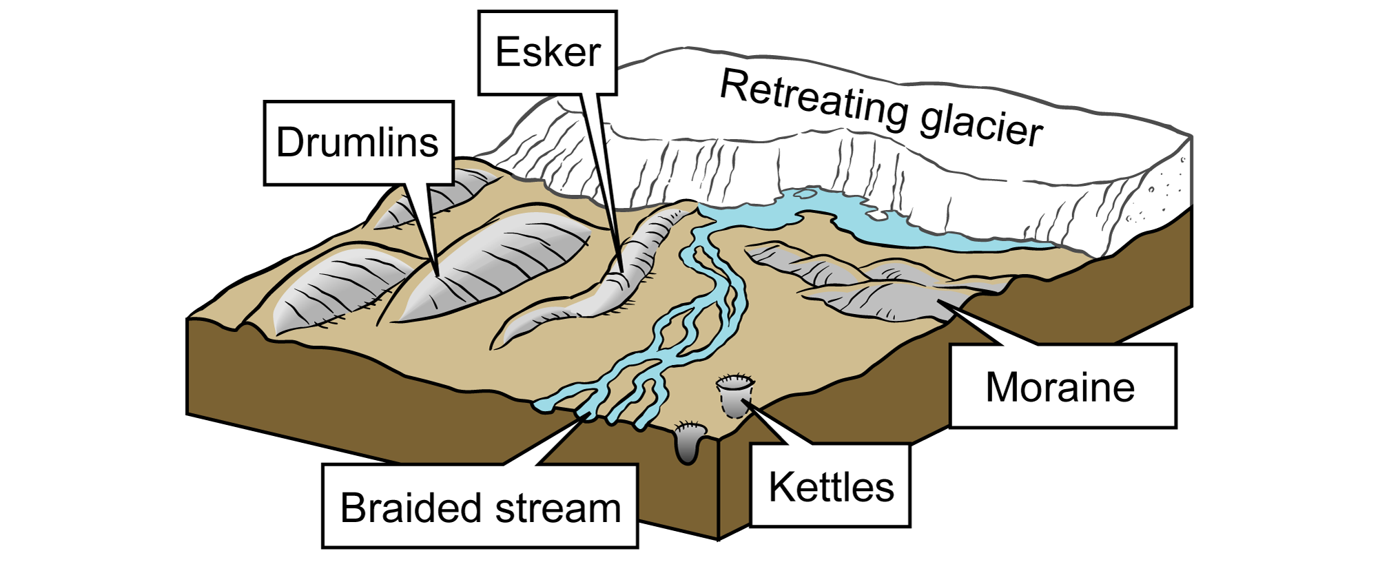
Examples of different types of glacial features. Image modified from original by J. Houghton first published in The Teacher-Friendly Guide to the Geology of the Northeastern U.S. by Jane Ansley (published by the Paleontological Research Institution) (CC BY-NC-SA 4.0 license).
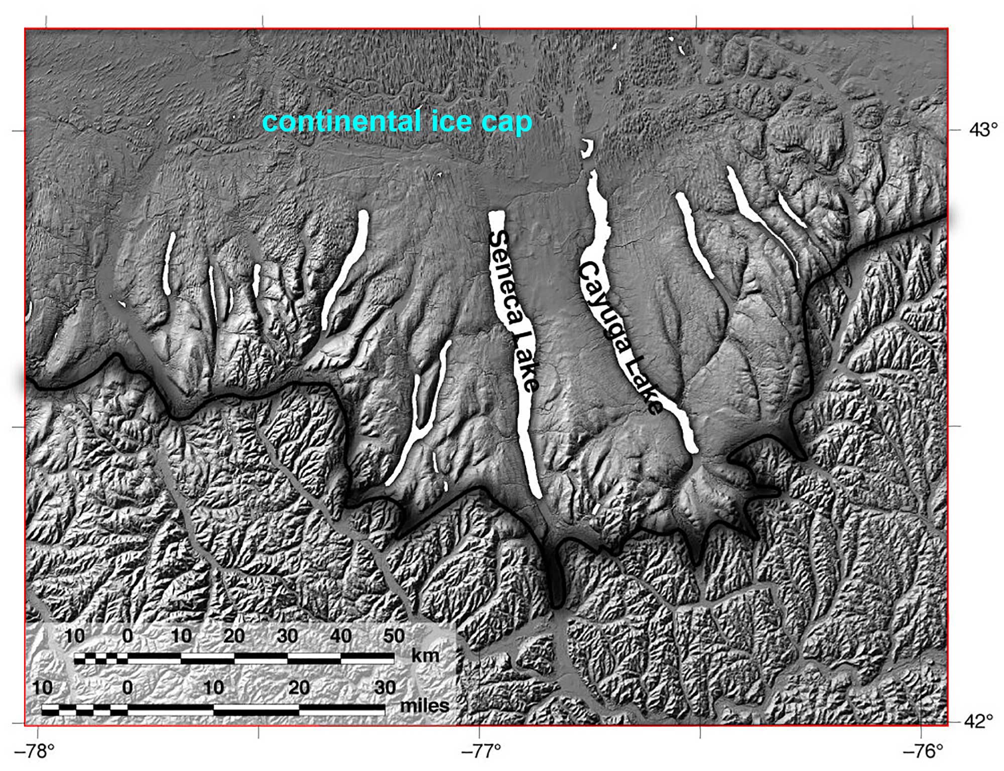
Extent of the Valley Heads moraine is indicated by the black line and represents maximum southern extent of the continental ice sheet during the most recent glaciation, approximately 17,000 years ago. Modified from Fig. 5.2 (created for educational use only by Rick Allmendinger) in the book Gorges History by Arthur Bloom (published in 2018 by the Paleontological Research Institution). Copyright Paleontological Research Institution.
Another are teardrop-shaped hills of glacial sediment called drumlins, which formed under the glacier as it advanced. Moraines are visible south of Ithaca at North Spencer, along Route 13 west of Newfield, and northeast of Ithaca between Dryden and Cortland. Drumlins are visible at the northern ends of Cayuga and Seneca lakes in a broad band from Rochester to Syracuse.
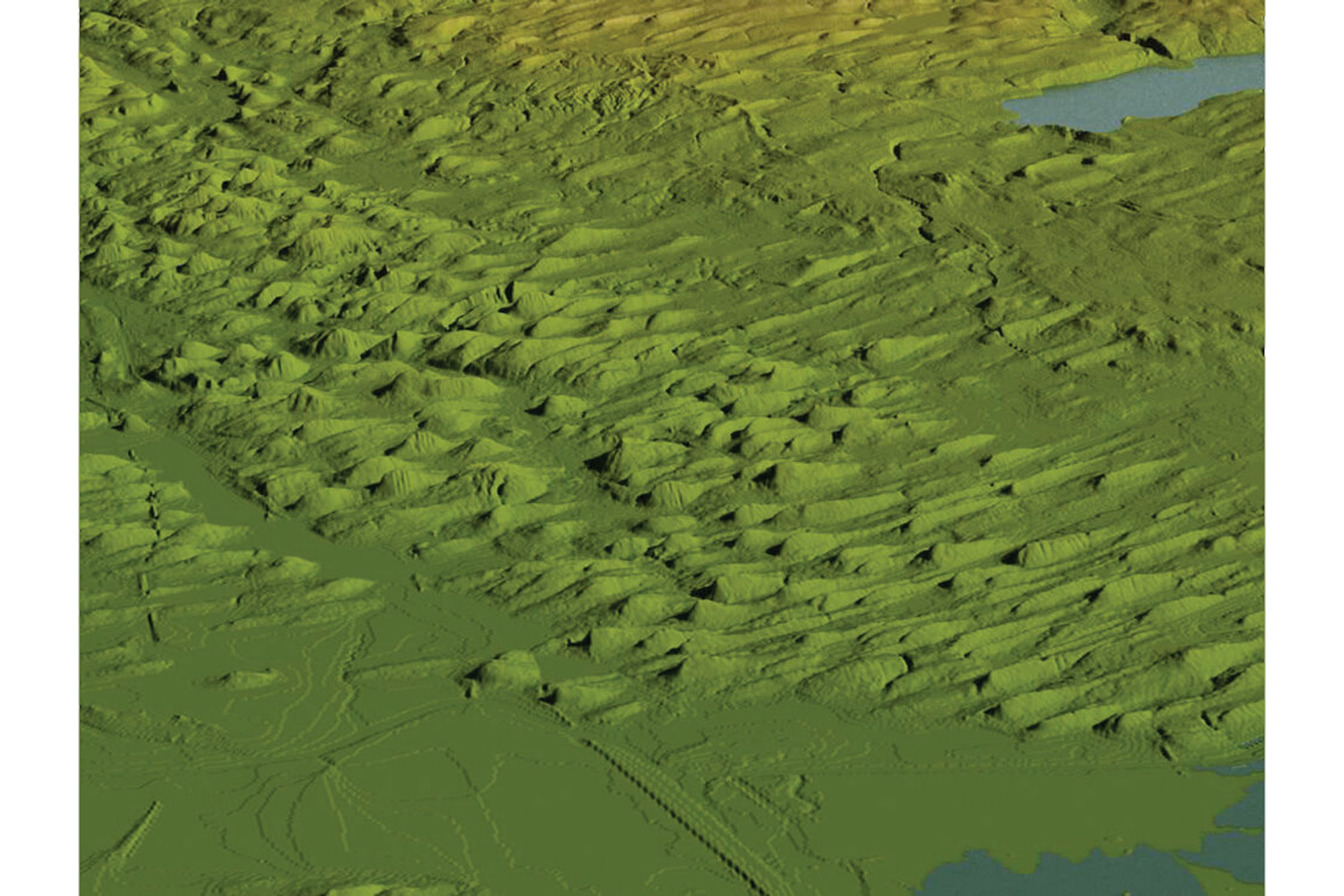
Drumlin field near Auburn, NY. The lake in the foreground is Cayuga Lake; Skaneatelus Lake is in the upper-right corner. Figure made by Rick Allmendinger for educational use only; published as Fig. 4.9 in the book Gorges History by Arthur Bloom (published in 2018 by the Paleontological Research Institution). Copyright Paleontological Research Institution.
The Devonian and glacial history of the Finger Lakes region are also responsible for the wine industry of the region. More than 50 vineyards are scattered around the central Finger Lakes, usually on the sloping sides of the lake valleys. The fractured shale and limestone enable the long roots of grape vines to penetrate deeply into the ground, and also keep the overlying soils well-drained. The topography of the lake valleys provide bands of appropriate climatic conditions (called microclimates), with temperatures and humidities appropriate for growing several European vinifera varieties. The lakes temper the upstate winters, often keeping vineyards considerably warmer than locations less than a mile away, and also moderate the transitions of spring and fall.
"Ithaca is Gorges" — Why?
The famous gorges of the Finger Lakes are a result of the interaction between the south-to-north-running river valleys, which were gouged by glaciers numerous times over the last 2 million years, and streams running perpendicular to the glaciers.
The story of the gorges began when the Finger Lakes were river valleys with small streams flowing in from the east and west. The valleys were repeatedly filled with hundreds of feet of glacial ice that originated from glaciers flowing south out of Canada, eroding the valleys more deeply.
When the glaciers melted back, and glacial sediment dammed the river valleys, lakes much deeper than those of today formed and streams plunged over waterfalls from the glacially steepened hills. As the lake levels dropped, a series of steps were left on the hillsides, like those seen at the top of Taughannock Falls. The streams eroded downward, forming the gorges so characteristic of the Finger Lakes region, in a process that continues today.
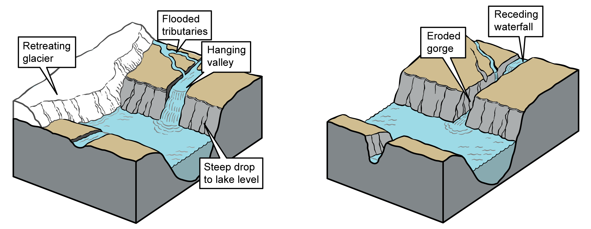
Left: Development of a hanging valley following glacial retreat. Right: Development of a post-glacial gorge as seen in the Finger Lakes region of central New York. Images modified from originals by J. Houghton first published in The Teacher-Friendly Guide to the Geology of the Northeastern U.S. by Jane Ansley (published by the Paleontological Research Institution) (CC BY-NC-SA 4.0 license).
The material that the streams eroded was deposited in large deltas at the mouths of the creeks. These deltas are clearly visible today at places such as Taughannock Falls State Park and Myers Point, near the southern end of Cayuga Lake. Some of the gorges were cut during earlier interglacials, filled with glacial sediment during ice advances, and then re-cut since the last glacial retreat.
Erosion of the gorges appears today to be mostly slow and gradual. There are rounded pebbles worn smooth by the water and occasionally rounded holes in the stream beds (called plunge pools and potholes) that have been scoured out by stones whirled around by the water. But things are not always as they seem. The flow of streams in upstate New York is highly seasonal, with high volume in the spring from snowmelt and low volume in the summer and fall. More erosion is likely to happen when there is more water flowing in the stream.
The rocks themselves reveal other signs that erosion is not always constant and gradual. The rocks around Ithaca are cut by thousands of ruler-straight cracks, which look like they have been cut with a saw.
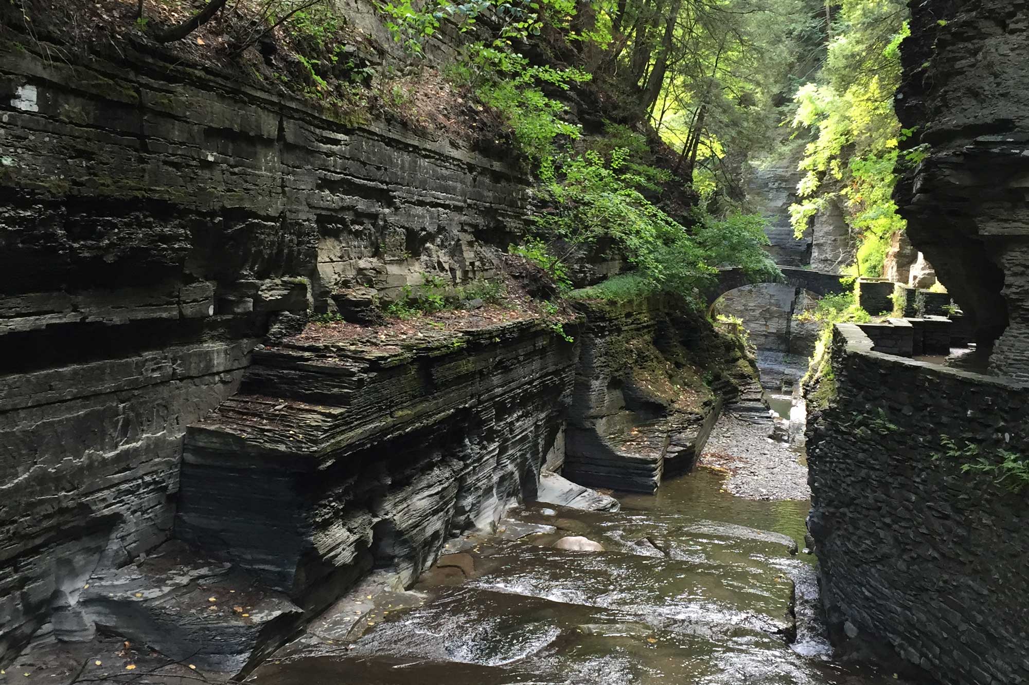
Flat joint surfaces visible on an exposure of Devonian siltstones at Robert H. Treman State Park (Tompkins County, NY) look as though they were cut by a saw. Instead, they are cracks formed by ancient tectonic events. Photograph by Jonathan R. Hendricks for PRI's Earth@Home project (CC BY-NC-SA 4.0 license).
These are natural fractures called joints. They are caused by stress of rocks on an enormous geographic scale, due to the collision of the continents more than 250 million years ago. These joints form weaknesses in the rocks of the gorge walls. Water seeps into the cracks, freezes, and expands. Eventually, catastrophic failure occurs, resulting in a rockslide. The broken rocks are then moved downstream by spring floods and eventually out into the main valley or lake. Look at the fracture patterns in the walls of the gorges. Look at the piles of rocks at the bases of the walls. You can see that the gorges formed by this system of small catastrophes and variation of flow in the streams.
Fossils of the Ithaca Area
Fossils are abundant in the Ithaca area, and easy to collect. Examples are shown below. All date from the Middle and Late Devonian Period, and all were buried in mud and sand that accumulated in a shallow sea between around 390-360 million years ago. Life in this warm ancient sea was abundant and diverse, just as in warm seas today, but the kinds of animals were very different. Fossils of many groups of organisms can be found, including more than 400 species. Many of these species are identified in David M. Linsley's work "Devonian Paleontology of New York," which was published by the Paleontological Research Institution in 1994. Linsley's 472 page tome is now out of print, but may be downloaded as a free PDF via the button below. A shorter, more accessible, version of this work titled "Field Guide to the Devonian Fossils of New York" By Karl Wilson is in print and may be purchased from the PRI online store.
Clams
Clams, or bivalves, are mollusks with two shells. Clams were common in the Devonian, but not as abundant or diverse as they are now.
Fossil specimen of the bivalve Grammysia elliptica from the Devonian Ithaca Formation of Tompkins County, New York (PRI 76731). Specimen is from the collections of the Paleontological Research Institution, Ithaca, New York. Longest dimension of specimen is approximately 5.5 cm.
Snails
Like bivalves and cephalopods, snails are also mollusks. Snails are scientifically known as gastropods. Most have coiled shells.
Fossil specimen of the gastropod Naticonema lineata from the Devonian Hamilton Group near Geneseo, New York (PRI 76749). Specimen is from the collections of the Paleontological Research Institution, Ithaca, New York. Maximum dimension of specimen is approximately 3.5 cm.
Cephalopods
Cephalopods are mollusks and today include squids, octopuses, and the chambered nautilus. Fossils of two kinds of cephalopods can be found in the rocks around Ithaca. Both have straight or coiled shells divided into separate chambers. Nautiloids have simple curved walls separating these chambers; ammonoids have more complex walls.
Fossil specimen of the nautiloid cephalopod Casteroceras alternatum from the Devonian Marcellus Shale (Cherry Valley Limestone Member) of Madison County, New York (PRI 5363). Specimen is part of the type and figured collections of the Paleontological Research Institution, Ithaca, New York. Length of specimen is approximately 25 cm.
Fossil specimen of the cephalopod Tornoceras uniangulare from the Devonian Geneseo Shale of Tompkins County, New York (PRI 55004). Specimen is from the collections of the Paleontological Research Institution, Ithaca, New York. Maximum diameter of specimen is approximately 6 cm.
Trilobites
Trilobites are an extinct group of animals related to living horseshoe crabs and lobsters. They look a bit like pill bugs or insects with their segmented bodies and sometimes compound eyes. Two kinds of trilobites are frequently found in rocks around Ithaca, and one is especially common. It is rare to find whole trilobites because most fossils are of the broken molted skins of growing individuals.
Fossil specimen of the trilobite Eldredgeops rana from the Devonian Ludlowville Formation of Genesee County, New York (PRI 49811). Specimen is from the collections of the Paleontological Research Institution, Ithaca, New York. Trilobite is approximately 3 cm in length.
Fossil specimen of the trilobite Dipleura dekayi from the Middle Devonian of Hamilton, New York (PRI 68155). Specimen is from the collections of the Paleontological Research Institution, Ithaca, New York. Specimen is approximately 15 cm in length.
Corals
Corals are of two kinds among the Devonian fossils of Ithaca: rugose or “horn” corals, and tabulate or “honeycomb” corals. Both of these types of corals are extinct, but they resemble modern corals in some ways.
Fossil specimen of the rugose coral Heliophyllum halli from the Middle Devonian Moscow Formation of Erie County, New York (PRI 70755). Specimen is from the collections of the Paleontological Research Institution, Ithaca, New York. Specimen is approximately 11 cm in length.
Fossil specimen of the tabulate coral Emmonsia emmonsii from the Devonian Onondaga Limestone of Genesee County, New York (PRI 76736). Specimen from the collections of the Paleontological Research Institution, Ithaca, New York. Longest dimension of specimen is approximately 8.5 cm.
Brachiopods
Brachiopods are the most common fossils in the area. Brachiopods have two shells, and superficially look like clams, but the internal anatomy of brachiopods reveals that they are actually a very different kind of animal. You can also identify your specimen as a brachiopod if each shell is symmetrical from side to side (clams are symmetrical from valve to valve, that is, each valve is a mirror image of the other). Brachiopods are still alive in oceans today but are much less common than they once were.
Fossil specimen of the brachiopod Mediospirifer audaculus from the Middle Devonian Moscow Formation of Livingston County, New York (PRI 70767). Specimen is from the collections of the Paleontological Research Institution, Ithaca, New York. Longest dimension of specimen is approximately 5 cm.
Fossil specimen of the brachiopod Tullypothyridina venustula from the Devonian Tully Limestone of New York State (PRI 70762). Specimen is from the collections of the Paleontological Research Institution, Ithaca, New York. Longest dimension of specimen is approximately 2.5 cm.
Fossil specimen of the brachiopod Athyris spiriferoides from the Devonian Ludlowville Formation of Erie County, New York (PRI 44050). Specimen is from the collections of the Paleontological Research Institution, Ithaca, New York.
Crinoids
Crinoids or sea lilies are not plants but are relatives of sea stars and sea urchins. They have a multiarmed head on a long, flexible stalk made of many discs. The discs are often individually preserved as fossils; heads are much less common.
Fossil specimens of the crinoid Melocrinus williamsi from the Devonian Ithaca Formation of Cortland County, New York. Specimen is from the collections of the Paleontological Research Institution, Ithaca, New York. Specimen preserves mineralized hard parts (stem segments) and external molds of stem segments and the calyx. Rock slab is approximately 29 cm in length.
Glass Sponges
Sponges are very simple animals that filter particles of food from the water column. Glass sponges, which have skeletons made of silica glass, are among the rarest fossils in the Devonian strata in the Ithaca area.
Fossil specimen of the glass sponge Hydnoceras tuberosum from the Devonian of Steuben County, New York (PRI 76741). Specimen is from the collections of the Paleontological Research Institution, Ithaca, New York. Length of specimen is approximately 26 cm.
Fossil specimen of the glass sponge Uphantaenia chemungensis from the Devonian Enfield Formation of Tompkins County, New York (PRI 76745). Specimen is from the collections of the Paleontological Research Institution, Ithaca, New York. Maximum diameter of specimen (not including surrounding rock matrix) is approximately 11.5 cm.
Pseudofossils: Concretions
Pseudofossils are structures in rock that look like fossils, but are not. The most commonly encountered pseudofossils in Central New York are rounded or irregularly shaped rocks called concretions.
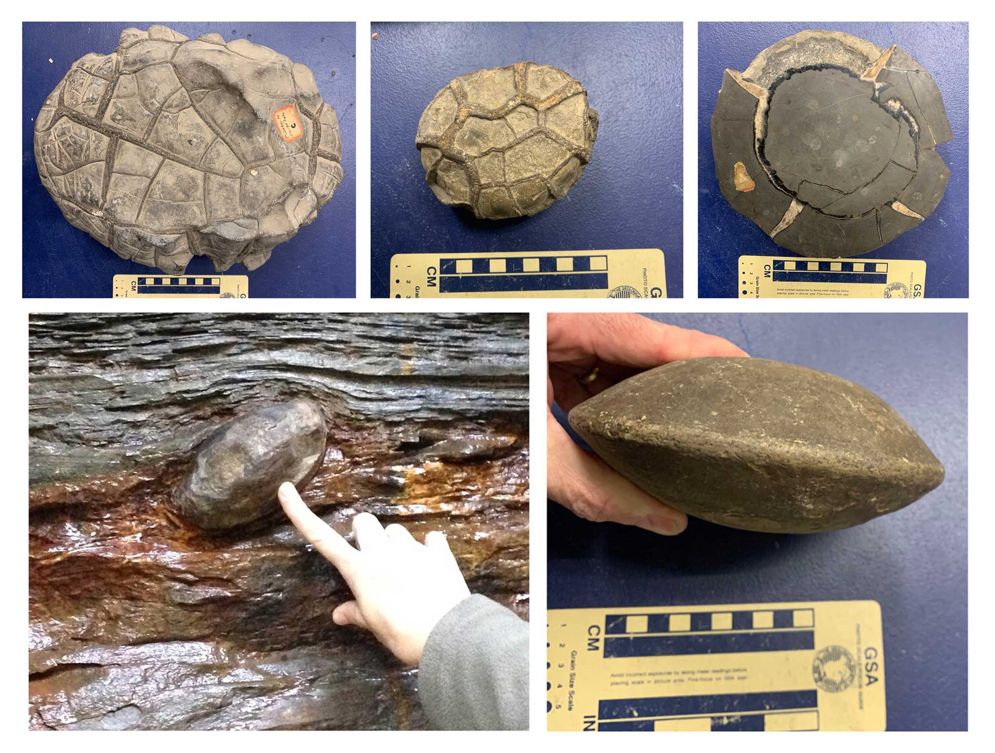
Top row: Examples of concretions in the PRI collections. The specimen on the left is from Crowbar Point near Cayuga Lake in New York. The specimen on the right shows interior features. Bottom row: Left: A calcareous concretion exposed in Devonian-aged sedimentary rock at Watkins Glen State Park, New York. Right: A calcareous concretion in the PRI collections. Photographs by PRI staff for the Earth@Home project (CC BY-NC-SA 4.0 license).
Often mistaken for fossil eggs, turtle shells, bones, or other organic structures, concretions are actually not fossils at all but a common geologic phenomenon in all types of sedimentary rock, especially in the shales and siltstones of central New York. Concretions form when minerals (such as calcium carbonate, which forms limestone) within soft sediment precipitate in successive layers around a nucleus such as a shell or pebble. Concretions made of calcium carbonate are thus actually masses of limestone that grew inside other sedimentary rocks. They are spherical to oval-shaped masses that are usually flattened parallel to the bedding planes of the surrounding rocks, but not as much as the less cemented rocks in which they formed. They can range in size from less than an inch to several feet (2.5-60 cm) in diameter. Sometimes the concretion will crack and the cracks will be filled with crystals, forming a rounded rock that looks amazingly like a turtle’s shell. When concretions erode out of the rocks in which they were formed, they are often dissolved by acidic rain or groundwater, forming odd shapes, and sometimes resembling fossils.
Collecting Fossils
Where to Collect
Fossils are present in varying abundance in almost all rocks in the Finger Lakes region. The rocks that are richest in fossils are frequently gray shales or fine-grained sandstone, or limestone. It is easiest to collect fossils from shales, because these rocks are rather soft and break apart easily into layers. You will find a greater variety of fossils if you collect from a variety of rock types and locations. You are most likely to find rocks abundantly exposed along stream beds, in quarries, or at road cuts. Penn Dixie Fossil Park & Nature Reserve, located in Blasdell, NY, just south of Buffalo, presents an opportunity for families to collect Devonian fossils for a modest fee. Although the site is outside the Finger Lakes region, the strata were deposited in the same ancient sea and many of the fossils are similar to those found in the Finger Lakes region. Occasional guided field trips to nearby fossil collecting locations are also offered by the Paleontological Research Institution.
How to Collect
A sharp eye and patience are the best tools for fossil hunting. If you wish to split apart soft rock, a butter knife or other flat-ended metal instrument is handy. More serious collectors often purchase hammers and chisels made specifically for the purpose of fossil collecting. Examine rocks closely for fossils, because many contain very small shells. Sometimes fractures in the rock can look deceivingly like fossils, so don’t be fooled! Usually once you have found a few well-preserved fossils (which in some places might take only a few minutes), what to look for will become clearer to you. An hour of collecting in a good locality could yield dozens of fossils. If you are serious about your collection, be sure to record where you found each fossil. If you find anything that you think might be scientifically significant, bring it to the attention of a professional geologist or paleontologist. You can also send pictures of your fossils to Paleontological Research Institution staff for an identification.
Please Note: Fossil collecting is a wonderful hobby that the whole family can enjoy, but it is important to use good safety precautions, especially with children. It is possible to be cut on rocks or to be injured by a rock shattered while hammering. To maximize safety, bring safe tools, eye protection, a basic first aid kit, water, and sunscreen on any collecting endeavor. Also note that many of the best collecting spots are on private land and are open only through the graciousness of the land owners. Always ask for permission from the land owner to collect, and always leave the area as you found it. This will help ensure that you and others can visit the site for collecting again someday. Collecting fossils and other natural history items in State Parks is prohibited.
Why Study Fossils?
Fossils are the easiest and best way to obtain relative dates for sedimentary rocks, and as such are essential for understanding the history of the Earth as well as for searching for resources in the Earth, especially petroleum. Fossils are also worth studying because they are the only record we have of the history of life on Earth, and they reveal much about the processes of evolution that were responsible for that history. Fossils tell us that our planet and its living things have experienced huge changes over more than 4 billion years, and they help us reconstruct why many of those changes occurred. Today, when changes in global climates and ecosystems are of great concern, fossils are a crucial source of information about how life responds to such change.